SBIR Phase I Final Report

SBIR Final Report
Tuesday, May 3, 2011
StreamWeaving is an innovative software processing architecture for multi-sensor imagery and metadata from tactical and national Intelligence, Surveillance, and Reconnaissance (ISR) assets.
StreamWeaving processes imagery and video from emerging ISR sensors, enabling users to quickly and intuitively, select and analyze data creating a realtime visualization of tactical imagery. Imagery processing pipelines are used for processing at ingest, and while serving, to allow the user to extract information from imagery. High performance processing can be achieved in the GPU using the OpenCL standard.
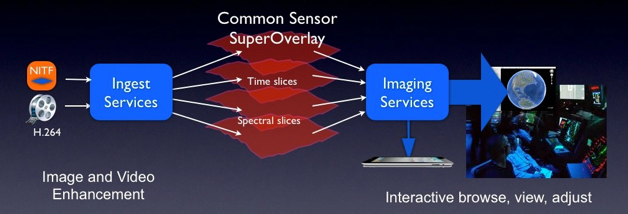
We demonstrated the feasibility of StreamWeaving’s Common Sensor SuperOverlay, using tactical imagery and simulated tactical video. Full frame Imagery tiles, processed tiles, video frames, and KML can be interactively browsed, viewed, and adjusted within a layered geospatial framework that easily integrates other geospatial intelligence.
Processing pipelines operate on image tiles and video frames to generate a real-time visualization overlay for standard geo-frameworks such as Google Earth Keyhole Markup Language (KML) or MapKit.
We submitted our public summary today

